The Texas Triangle, between Houston, Dallas and San Antonio, is home to 75% of Texans
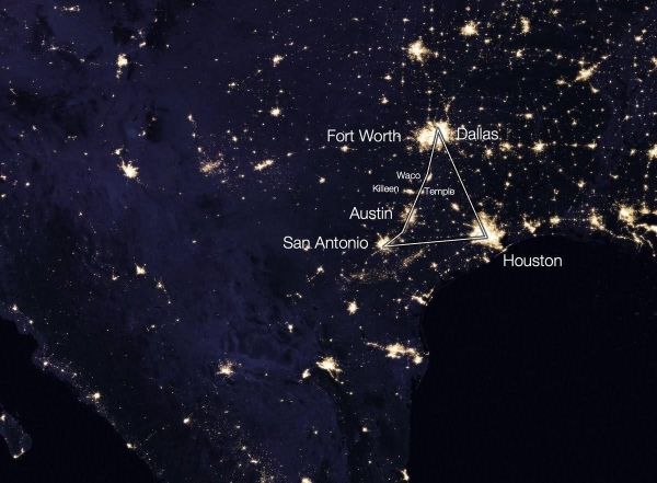
The night lights map shows that people are concentrated at its peaks and edges. One of its peaks is the huge Houston. The other top is an unusual type of city: the Dallas-Fort Worth pair. Then there is the line of cities between Dallas and San Antonio: Austin, Waco...However, why is most of the population of Texas concentrated in this area? The answer may be provided by a satellite map that shows a green-gray line running from San Antonio to Dallas. This fall line turns mountains into hills that can be crossed. Many of Texas's most important cities lie on the fall line of the Edwards Plateau. They form the gray line in the satellite image. But why did these cities arise at these particular points on this line, and not at others? Each is at the intersection of this fall line with the river: San Antonio on the San Antonio River, Austin on the Colorado River, Waco on the Brazos River, Fort Worth and Dallas on the Trinity River. Thus, the rivers and fall line of the Edwards Plateau created the conditions for the development of these cities and attracted many people to the region. The problem with these rivers is that they are not very navigable. They brought water and irrigation to cities - hence their origins - but their transportation options were limited. That is why Texas intensively developed its railroads. The late 19th century saw both enormous railroad construction and the discovery of oil. Both began the growth of the population of Texas. That's why one end of the Texas Triangle is so populated.
But why is the other end in Houston? Usually there is only one large port in each region, because it is advantageous for all goods to go to one center. And natural bays are usually where they occur, protected by the ocean. In the 1800s, Houston was not the largest port in Texas. This was Galveston, founded by Mexicans in 1825. Galveston grew due to its location: a large bay area, close to North Orleans and other major Texas cities. In 1900, Galveston learned a lesson that other regions had learned over centuries of storms: Galveston was too close to the sea. It suffered from a hurricane that devastated it. The port and industrial enterprises moved deeper into the city as far as possible. This was Houston. It was located at the confluence of two navigable bays, invested in improving their navigability, and received one of the first railroads on the route to Galveston. It had all the necessary infrastructure and was close to Galveston. The ideal successor. Other ports found it difficult to compete.
Let's recap why 75% of Texans live in the Triangle. The first reason is the end of the Edwards Plateau, where the land becomes flat terrain. This makes transportation easier and the area more accessible for residents and businesses. The second reason is Houston, the main city in this zone. Thus, a combination of geographic and historical factors has made the Triangle an attractive place to live and do business.
Author: Elina Linderman